


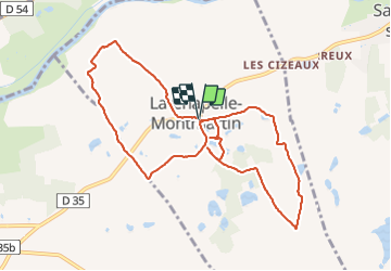
rando la chapelle mont Martin

lecmic
User

Length
10.2 km

Max alt
127 m

Uphill gradient
92 m
Km-Effort
11.4 km

Min alt
79 m

Downhill gradient
92 m
Boucle
Yes
Creation date :
2022-03-22 07:11:36.166
Updated on :
2022-03-22 10:15:24.778
2h29
Difficulty : Very easy

FREE GPS app for hiking
 SityTrail
IGN / Geographical institutes
SityTrail Plus
The world is yours!
About
Trail Nordic walking of 10.2 km to be discovered at Centre-Loire Valley, Loir-et-Cher, La Chapelle-Montmartin. This trail is proposed by lecmic.
Description
marche nordique
Positioning
Country:
France
Region :
Centre-Loire Valley
Department/Province :
Loir-et-Cher
Municipality :
La Chapelle-Montmartin
Location:
Unknown
Start:(Dec)
Start:(UTM)
404606 ; 5235946 (31T) N.
Comments